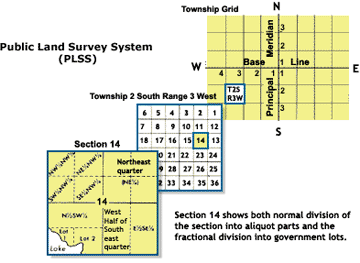
Section, Township, and Range
The Public Land Survey System (PLSS) typically divides land into 6-mile-square townships, which is the level of information included in the National Atlas. Townships are subdivided into 36 sections, each normally one square mile in area and containing 640 acres(2.6 km²). Sections can be further subdivided into quarter sections, quarter-quarter sections, or irregular government lots. Normally, a permanent monument, or marker, is placed at each section corner.
Source: U.S. Department of the Interior / Bureau of Land Management / Public Land Survey System; last update: 2007.PLSS Illustration:
